Main activity is the geophysical research in many fields: gravimetry, magnetometry, electrical prospecting, topo-hydrography.
Research activities:
- Gravity and magnetic mapping of the Romanian Black Sea continental shelf and other
marine areas, including the land – sea transition zone;
- Geological interpretation of geophysical data by 2D and 3D modeling;
- Environmental and engineering geophysics;
- Archaeogeophysics;
- Topodydrography – for the enhancement of hydrotehnic works and electronic navigation maps;
- Geophysical data bases and GIS applications;
- Coordination of research projects for CO2 Capture and Geological Storage, as engineering method to diminish greenhouse gas fluxes with climate change effects.
The laboratory is involved in several research projects:
- National research projects: CERES, MENER, CEEX
- Romanian Academy research grants
- Contracts for geophysical works with Romanian companies and other organizations: PETROM, Romgaz SA, Prospectiuni SA, Intergis Grup SRL, as well as for the Romanian Museum for National History
- European Commission Framework Programme VI (FP6): CASTOR, EU GeoCapacity, CO2 Net East
- Contracts for geophysical works with foreign companies: PALADIN Expro Ltd.-UK, BRGM – France
- MEBE European project (Middle East Basin Evolution)
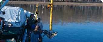
Laboratory equipment
- On bottom marine gravity meters, GD-K model (two equipments) – 1980, for 0-300 m depth range, measurements interval: 100-6000 mgal
- On board marine gravity meters: GMN K model – 1984 and GMN KM model – 1987, measurements range: 500 – 7000 mgal
- Geometrics Marine protonic magnetometer, G-877 model – 2002
- Geometrics Land protonic magnetometers, G 856 – 2002, G 856 – 2004
- Ceeducer Integrated bathymetry system – 2002, depth range: 0.3 – 100m
- Interphase Echo-sounder – 1999
- Topography equipment – GPS and Total Station, theodolites, topography gauges, different types of compasses
- IBM compatible computers and peripherals
- Electrometry system with automatic data acquisition
- Specialized computer software: Oasis montaj and GM SYS, AutoCAD Map 3D, Raster Design, Global Mapper
 Romana


